
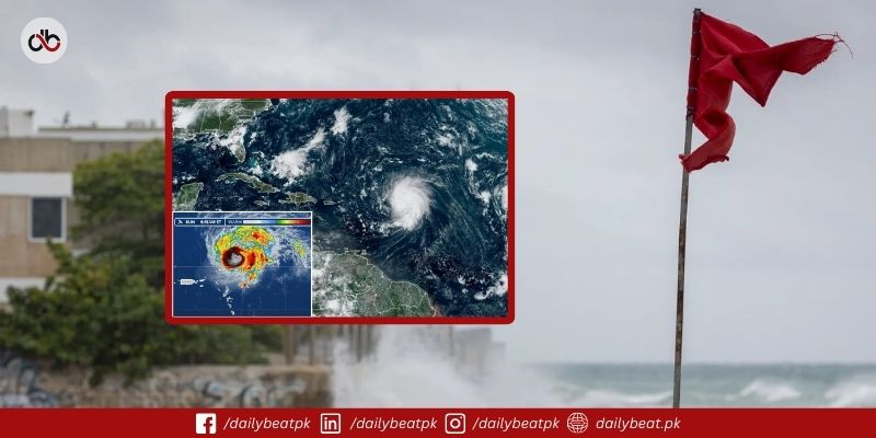
Hurricane Erin restrengthens into a powerful Category 4 storm as it moves through the Caribbean, bringing heavy rain and strong winds. The storm is the first major hurricane of the Atlantic season, which forecasters warn will likely be more active than usual.
The Miami-based National Hurricane Center (NHC) reported Erin late Sunday about 130 miles east of Grand Turk Island. Its maximum sustained winds reached 130 miles per hour, with warnings issued for the southeastern Bahamas and Turks and Caicos Islands.
The core of the hurricane is expected to pass east and northeast of the islands, but forecasters warned of flash floods, landslides, and dangerous surf conditions. Rainfall could reach up to six inches in some areas, raising concerns of urban flooding and mudslides.
Although Erin is not predicted to make landfall, its impact will extend across the region. The storm is expected to grow in size even if it weakens slightly in the coming days. Coastal regions of Bermuda, North Carolina’s Outer Banks, and parts of the central Bahamas are advised to monitor updates closely.
The hurricane briefly reached Category 5 status earlier, showing rapid intensification within just over a day. Scientists say such rapid strengthening is becoming more frequent due to rising sea surface temperatures linked to climate change.
In Puerto Rico, flooding has already affected roads and homes, while strong swells are expected to spread toward the Bahamas, Bermuda, and the east coasts of the United States and Canada. These swells could create life-threatening rip currents and coastal erosion.
The Atlantic hurricane season, which runs until late November, is forecast to be intense. Last year, several destructive storms hit the region, including Hurricane Helene, which caused more than 200 deaths in the southeastern United States. Experts warn that warming oceans could fuel more storms like Erin in the years ahead.
Explore the full details of the PM Laptop Loan Scheme 2025 on PM Laptop Loan Scheme 2025: Registration, Eligibility & More.